
Two Low Pressure Areas Bring Rains to Northern Luzon
A low pressure area off Balaoan, La Union brings rainy weather across Northern Luzon.
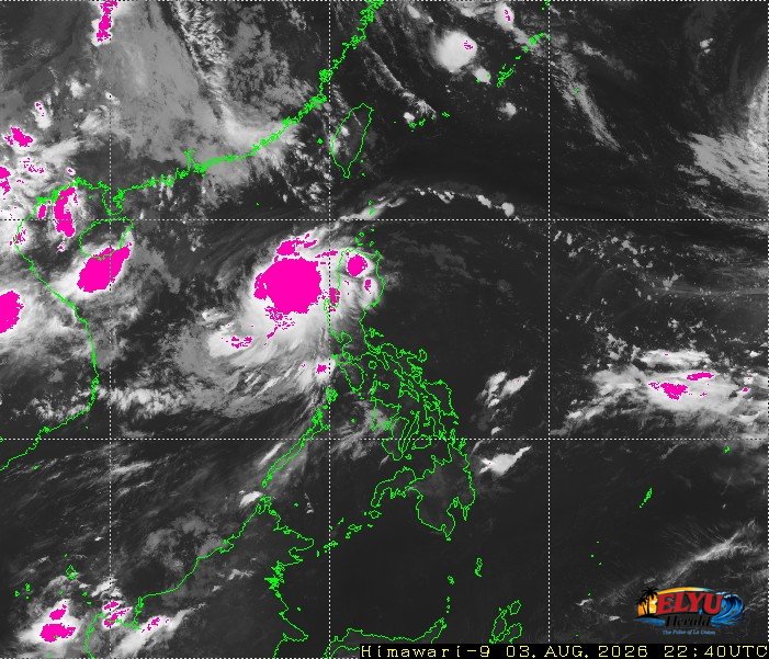
Satellite Screenshot Source: Meteorological Satellite Center of JMA website
PAGASA says, two low pressure areas and the southwest monsoon are bringing cloudy skies, scattered rains, and thunderstorms across Luzon and parts of the Visayas on August 4, 2026, raising risks of flash floods and landslides.
PAGASA experts placed one low pressure area over the coastal waters of Balaoan, La Union, while a second low pressure system was estimated in the vicinity of Baggao, Cagayan. The combined effects of these weather systems are driving moderate to heavy rainfall across several northern regions.
The areas expected to experience scattered rains and thunderstorms from the low pressure areas include:
- Ilocos Region
- Cordillera Administrative Region
- Cagayan Valley
- Central Luzon
Coastal communities along Northern and Central Luzon, including the waters off La Union, face moderate to rough sea conditions with wave heights ranging between 1.2 and 2.8 meters. Winds across these northern areas are forecast to blow moderate to strong from the northeast to northwest.
In other parts of the country, the Southwest Monsoon is affecting Southern Luzon and Western Visayas, causing scattered rainshowers over Metro Manila, CALABARZON, MIMAROPA, and portions of Western Visayas.
Typhoon Dolphin is still outside the Philippine Area of Responsibility and was tracked 2,330 kilometers east-northeast of extreme Northern Luzon moving westward at 25 km/h. The typhoon maintains maximum sustained winds of 150 km/h near its center with gustiness of up to 185 km/h.
SOURCE: PAGASA