
Kiyapo Still Brings Rains and Thunderstorms Across Northern Luzon
Trough of Typhoon Kiyapo brings scattered rains and potential flood risks to La Union residents.
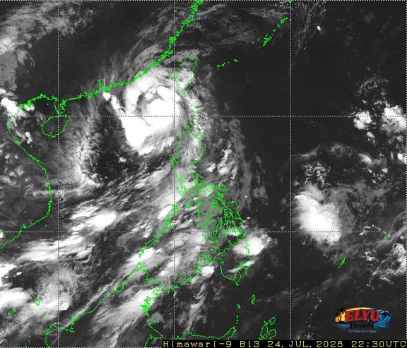
Satellite Screenshot Source: Meteorological Satellite Center of JMA website
According to PAGASA, Typhoon KIYAPO (international name NOUL) was spotted 310 kilometers west of Basco, Batanes as of 3:00 AM on July 25, 2026, moving west-northwestward at 25 kilometers per hour. The storm carries maximum sustained winds of 120 kilometers per hour near the center and gusts reaching up to 150 kilometers per hour.
While direct strong winds affect extreme Northern Luzon, the extended cloud band or trough of Typhoon KIYAPO is bringing cloudy skies with scattered rains and thunderstorms across La Union and the rest of the Ilocos Region. State weather forecasters warned that continuous moderate to heavy rainfall may trigger flash floods or landslides in low-lying and slope-prone areas in the province.
PAGASA outlined the following regional weather impacts:
- Ilocos Norte, Batanes, and Babuyan Islands: Experiencing direct rains with gusty winds and a minimal to minor threat to life and property from strong winds.
- La Union, Cordillera Administrative Region, and the rest of Ilocos and Cagayan Valley: Facing overcast skies with scattered rain showers and thunderstorms caused by the trough of Typhoon KIYAPO.
- Zambales, Bataan, and Occidental Mindoro: Experiencing occasional heavy rains driven by the enhanced Southwest Monsoon.
Coastal waters along Northern and Central Luzon are forecasted to remain slight to moderate, with wave heights ranging from 0.6 to 2.1 meters. Disaster response units in La Union advise residents near rivers and landslide-susceptible hillsides to remain vigilant and monitor official weather advisories.
SOURCE: PAGASA