
Super Typhoon Inday Tracks Westward East of Northern Luzon
La Union braces for localized thunderstorms as the super typhoon maintains its strength
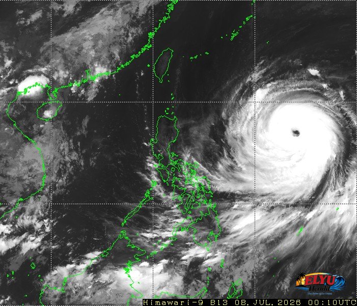
Screenshot of Himawari-9 viewer, credit Meteorological Satellite Center / Japan Meteorological Agency (JMA)
According to PAGASA, Super Typhoon Inday (Bavi) was located 1,420 kilometers east of Northern Luzon at 3:00 AM today, July 8, 2026, packing maximum sustained winds of 185 kilometers per hour and gusts of up to 230 kilometers per hour. The weather bureau reported that the storm is currently moving westward at a speed of 25 kilometers per hour. While the typhoon remains far from the landmass, it continues to influence regional weather patterns across the country.
In La Union, local disaster management offices are monitoring the weather as localized thunderstorms are expected to bring partly cloudy to cloudy skies with isolated rainshowers. Coastal and upland areas in San Fernando City, San Juan, and Bauang may experience sudden heavy downpours. These sudden rains carry the risk of flash floods and landslides during severe thunderstorm activity.
The state weather bureau outlined the following forecast conditions for Luzon and surrounding waters:
- Localized thunderstorms will bring scattered rainshowers across Metro Manila and the rest of Luzon, including the Ilocos Region.
- Light to moderate winds blowing from the northwest to west will prevail over the western section of Luzon.
- Slight to moderate coastal waters with wave heights ranging from 0.6 to 1.5 meters are expected along the western seaboard, affecting local fisherfolk.
Meanwhile, the Southwest Monsoon continues to affect Mindanao, the Western Visayas, and Palawan, bringing cloudy skies with scattered rains. PAGASA advises residents in vulnerable areas to monitor official updates and prepare for sudden weather changes.
SOURCE: PAGASA